US scientists report breakthrough in predicting hurricanes
US scientists are working on a question that baffles weather forecasters.
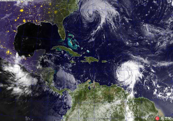
A handout made available by the US Navy shows a GOES satellite image of Hurricanes Jose (top) in the Atlantic Ocean and Maria in the Carribean Sea, 18 September 2017. [Photo: IC]
Researchers at the National Oceanographic and Atmospheric Administration in Miami think they may have figured out how to better predict when a tropical cyclone will rapidly intensify, and when it won't.
The breakthrough could help emergency officials worldwide issue earlier warnings to residents in the paths of storms.
These scientists have good reason to be concerned about hurricanes.
Their office is in Florida - one of America's most vulnerable places for hurricanes - the name given to powerful tropical cyclones in the North Atlantic.
Just last year, Hurricane Irma caused devastation this part of the US, and Hurricane Maria's rampage through the Caribbean left a trail of destruction in Puerto Rico and other islands.
Up until now weather forecasters have struggled to predict how such storms might strengthen.
"In some of these cases they can't tell 24 hours, 48 hours in advance whether or not this rapid intensification is going to occur."
That's Gus Alaka - a scientist with the US National Oceanographic and Atmospheric Administration's meteorological lab.
He says until fairly recently, forecasters relied almost entirely on readings of upper level winds - known as shear - to guide them. The stronger those winds, the more they damage the structure of a tropical system, making it less likely to develop into a full blown storm.
"Hurricanes like to be upright when they're spinning and whenever they're knocked over and tilted on their side that makes them less efficient. Hurricanes are heat engines so that makes them less efficient. And in that process they don't intensify as much, and in some cases they don't develop at all," Alaka says.
Now, meteorologist, Sundararaman Gopalakrishnan, says data from aircraft missions and satellites are giving a better-than-ever view inside the heart of hurricanes.
"It's like looking at a high resolution TV, basically you are focusing exactly on the spot where you can look at the action. Twenty years back we didn't have neither the resolution nor the technology to even look at the spots of the hurricane because of poorer resolutions in the models. Now we can focus in areas of interest and try to understand and see how we can improve from there."
And what these scientists are finding is changing their understanding of how these storms strengthen.
"We can see all sorts of battles between the environment and different vortices throughout the entire model…"
Alaka says in cases where a tropical system is competing against moderate wind shear, clouds deep inside the circulation can sometimes overcome the force of those winds that are trying to knock the cyclone over.
"We're really talking about deep clouds, deep thunderstorm clouds that are forming within the hurricane's inner core. The more symmetric these deep clouds can be, the better off the storm is going to be for intensification. The more likely that intensification process is."
He says gaining a deeper understanding of that internal battle is key to improving intensification forecasts.
"I'm reminded of this case - Hurricane Joaquin. Early on in Joaquin's lifetime it was a very weak system and the forecasts were not predicting a home run intensification process. There was no indication that this was definitely going to happen. But some of them were predicting a major hurricane. And sure enough, within 2 days the storm had rapidly intensified and we had a category 4, major hurricane sitting at the Bahamas. Those are the situations that cause the greatest concern and really motivate us to get better and better. For this situation where you don't even have a hurricane yet and maybe you have a category 4 bearing down on the United States, that's a huge question for citizens and emergency managers trying to make the right call."
It's hoped more accurate intensity forecasts will make it easier to predict in the future where hurricane damage will be worst - allowing first responders to move resources in earlier.
The Atlantic Hurricane season officially begins on June 1st.
Your Comment
Name E-mailRelated News
-
-
U.S. says to expel 2 Venezuelan diplomats in retaliation
U.S. State Department on Wednesday announced a decision to expel two senior Venezuelan diplomats in the United States in retaliation of Venezuela's earlier expulsion of two U.S. diplomats.
-
-
U.S.-led coalition targets Syrian military positions in desert region
The U.S.-led warplanes struck two Syrian military positions in the desert region in eastern Syria early Thursday, the War Media of the Syrian army and its allies reported.
-
-
U.S. Justice Department starts probe into Trump's FBI accusation
The U.S. Department of Justice said it has asked its watchdog, the Inspector General, to probe President Donald Trump's accusations that his campaign had been "infiltrated or surveilled" by the FBI during the 2016 elections.
-
-
U.S. secretary of state admits failure to reach deal with Europe on JCPOA
U.S. Secretary of State Mike Pompeo said on Sunday that the United States had failed to reach an agreement with the European nations on the historic Iran nuclear deal.